Файл:Новая Земля nasa image07052008 md.jpg

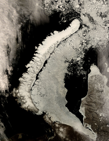
Новая Земля, снимок НАСА 23 июня 2008, разрешение 250 м.
The Russian archipelago Novaya Zemlya is featured in this image, captured by the MODIS on the Terra satellite on June 23, 2008. Novaya Zemlya consists of some small islands and two major ones that are separated by the narrow Matochkin Strait. The strait is barely visible in this image because of all the ice and snow, but you can see it about 2/3 of the way down the length of the narrow strip of land. The northern island is called Severny and the southern one is Yuzhny.
The archipelago is in the Arctic Ocean, in the north of Russia, and also serves as the separation between the Barents (west) and Kara (east) Seas. The Kara sea is filled with ice in this image. The interior of the islands is mountainous- the northern island, which looks smoother in the satellite image, contains glaciers.
Источник:modis.gsfc.nasa.gov/gallery/images/image07052008_250m.jpg ([1])
История файла
Нажмите на дату/время, чтобы просмотреть, как тогда выглядел файл.
| Дата/время | Миниатюра | Размеры | Участник | Примечание | |
|---|---|---|---|---|---|
| текущий | 18:29, 5 июля 2008 | | 3400 × 4400 (2,52 МБ) | EvgBot (обсуждение | вклад) | |
| 17:38, 5 июля 2008 |  | 337 × 436 (128 КБ) | EvgBot (обсуждение | вклад) | Источник: modis.gsfc.nasa.gov/gallery/images/image07052008_md.jpg ([http://modis.gsfc.nasa.gov/gallery/individual.php?db_date=2008-07-05]) {{PD-NASA}} Категория:Арктика Категория:острова [[Категори� |
- Вы не можете перезаписать этот файл.
Использование файла
Следующая 1 страница ссылается на данный файл: